Seas of Clouds
“I am losing precious days. I am degenerating into a machine for making money. I am learning nothing in this trivial world of men. I must break away and get out into the mountains to learn the news”
-John Muir
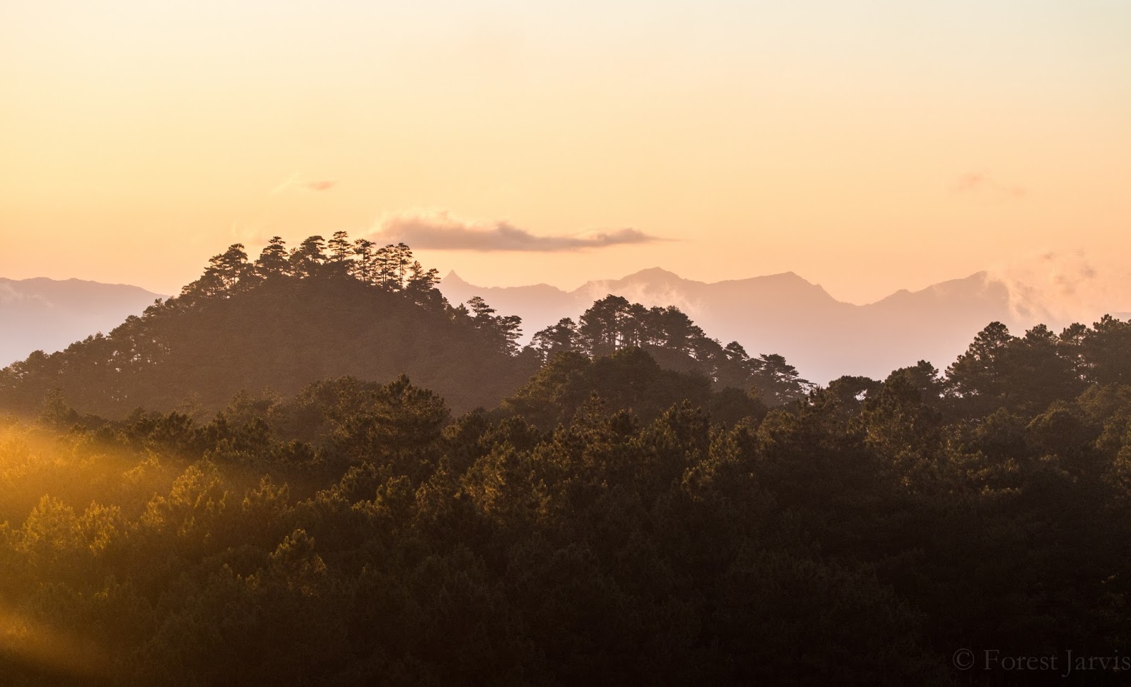
One of the many random contradictions of my life is that, despite the fact that I routinely seek out places that are in the tropics and/or swelteringly hot, I've always been more of a cold weather person. I grew up in Northern Michigan and went to school in Vermont. I'm usually one of the last people to put on a coat every fall. I'm good at cold weather. Needless to say, the Philippines isn't exactly the country for me. People here joke that there are three seasons in Manila: mainit, mas mainit, and masyadong mainit (hot, hotter, and too hot). Personally I'd argue that weather is pretty much always in the masyadong mainit range, but that's just me. So, when I found out that Grace and Lauren, two of the other Fulbright scholars in the Philippines, were going up to Baguio, a city in the mountains known for having a cool (read: survivable) climate, I had to tag along.
Baguio is one of the larger cities in the Philippines, and is unique in that it wasn't established by the Spanish or Filipinos, but rather in 1900 by the Americans as the "Summer Capital" of the new colony- a city with a cool climate to escape to when heat in the lowlands becomes too severe. It turns out this was a fairly common practice in European colonies, particularly in Asia, with almost every former colony having at least one. Turns out white people are really good at invading countries and raiding them for their resources, but not quite so good at staying in them comfortably once they've taken over.
Anyway, as such, Baguio has a much more American feel than most other places, with much of the original infrastructure still in place from the American era. And yes, it also had a wonderfully cool climate. I mean, it says a lot that 75 degrees fahrenheit has suddenly become "cool weather" for me, but it was definitely nice to be able to wear long pants comfortably for the first time in months. It was also incredibly refreshing to be up in the mountains again. There's something about the feeling of wind, fresh air, and even even the burn in my legs as I'm climbing yet another hill to get somewhere that I'll always miss. Maybe I'm just a fan of being closer to the sky.


Unfortunately, the above three pictures are about all I got to see of Baguio City proper; my departure from Manila was delayed for a day because of a meeting I couldn't miss, so I missed the city tour and sightseeing day. Instead, my first day there we headed up to Camp John Hay, in the mountains above Baguio. Originally called John Hay Air Station, it was established as a recreation facility for American soldiers on leave from active duty. During World War II, it was first used as an internment camp for the Japanese-Filipino residents of Baguio. When the Japanese began bombing the city and preparing to invade by land, the American troops left the city without defending it, and abandoned all the prisoners locked inside with no food or water. They were provided with supplies by American and Filipino civilians who had stayed behind, until the arrival of Japanese troops. After that, it was used as an internment camp for Americans instead until the end of the war, with little provided in the form of food or clean water. War really sucks, is kind of what I'm saying here.
After Filipino independence, it became a recreation center for all the residents of Baguio. Today, it feels very much like the American camp it once was- the buildings are the same, they have activities like zip-lining and horseback riding, and even the pine forest feels like it could have been taken straight out of the summer camp half the people reading this probably went to when they were kids. We first decided to explore the various "forest rides", which include the aforementioned zipline and slower things like the "canopy ride" or trekking. Since it's hard to take pictures while you're on a zipline, we decided to go for the slow stuff. Which, as it turned out, was very slow. The canopy ride was a ride down a hill on hanging chairs, with decent views of the mountains around us, and the "trekking" was walking about 200 feet to a skywalk, then walking back. In all honesty it probably wasn't worth the $8 or so we paid for it, but it was still fun.

 |
| Lauren and Grace on the exhilarating canopy ride. |
After the "rides", Grace and Lauren decided to go do the horseback riding, but since I have a pretty severe aversion to horses (long story), I just decided to walk around the camp and explore a little bit. Really, it was a good excuse to be walking around outside and not be sweating the whole time.
 |
| Mountain shrike (Lanius validirostris)- the first bird I've photographed that wasn't immediately described as "common" in the bird guides. (Note from 2022 Forest: This is actually a Long-tailed Shrike. 2015 Forest was a much better landscape photographer and a much worse birder.) |
 |
| Brown shrike (Lanius cristatus)- this one, uh, was described as "common". It eats bats though, so that's cool. |
 |
| I had to climb down a very steep hill, wade through a bunch of underbrush, and almost stepped on a dead cat to get to this lake. Not sure if it was worth it. |

Ever since we decided to head up to Baguio, we had entertained the idea of climbing Mount Pulag, the highest mountain on the island of Luzon and third-highest mountain in the Philippines. Of course, this never really developed beyond a vague "oh yeah we should climb Mount Pulag" until the day before we were hoping to make the climb. As it turns out, Pulag is located three hours away from Baguio, you have to get prior approval to climb it, and it's required to spend the night somewhere before or during the climb. Not that we knew any of this. Thankfully, I decided to call the phone number provided on a mountaineering blog, which turned out to be the cellphone of the park ranger in charge of directing climbers where to go. We had a brief and confusing phone call that got cut out by bad signal, where I learned that there were no more spots for camping the next day, as it was a weekend, so our only option was to head there that evening and stay the night below the mountain to do an early morning hike. So, after a dangerously minimal bit of thought, we packed our bags and headed to the van terminal to see if there was a van going to the right place.
As luck would have it, we ended up being the last three people able to fit on the last van heading in the right direction. Now, those who know me are aware that I'm not exactly built to fit well in planes, buses, or really anything else with seats smaller than your average armchair. I basically have two options for sitting: with my feet on the floor and a perfectly straight back as my legs are already bumping the seat in front of me, or in an awkward vertical fetal position with my shins against the seatback. In the first position I can't rest my head and my back starts to hurt, and in the second position I lose blood flow to my feet and my butt starts to fall asleep. Also, as a tall person my center of gravity is way higher, so I swing back and forth pretty dramatically any time the vehicle goes around a curve. I've been told that other people can do weird things like "extend their legs" or "sleep" while traveling, but that's not something I'm very familiar with. Anyway, the van was similar to that experience, except there was so little legroom I was stuck in an even-less-comfortable combination of the two aforementioned postures. Even better, it was completely dark, and we didn't actually know where we were supposed to get off. Thankfully, we struck up conversation with an old man in the seat behind me, who, it turned out, was going to the same place.
Our new friend ushered us out of the van in the town of Ambangeg, on the eastern slope of the mountain. We had planned to immediately meet with the park ranger, but when it was discovered that we hadn't eaten yet, our de facto guide instead insisted on taking us up to the local university, where we were welcomed by a large group of drunken professors, and the cook of the school kitchen who plied us with vast amounts of noodles and fruits until she was satisfied we were full. Only after we had eaten were we shown to the park ranger's office, where we payed our registration fee (about $4) and found someone who would drive us up to the trailhead the next morning. After that, we were shown to our accommodations, a decent cottage for hikers or university visitors that somehow hadn't been taken yet. I should point out that at no point did we have any idea what we were supposed to be doing or where we were supposed to go; things just sort of worked out for us. You could call it the fault of my really weird luck, or more likely attribute it to the fact that the people on Mount Pulag were very familiar with helping out idiot tourists who had no idea what they were doing.
We woke up the next morning at 12:30 AM (yes, you read that right), and, after a very bumpy motorbike ride a ways up the mountain, began the actual hike a little before 2 in the morning. Normal people hike most of the way up during the afternoon, camp on the side of the mountain, and finish it the next morning before sunrise. However, since we weren't smart enough to reserve more than a few hours in advance, we had to do the entire hike in one go. Since Mount Pulag is in a protected area that belongs to a number of different indigenous Filipino ethnic groups, we were required to have a guide along with us from one of the local communities. Our guide, Pedrito, was a spry Ibaloi man who, despite the fact he was probably older than the three of us put together, climbed Mount Pulag nearly every day, and was probably a little frustrated by all of our bumbling. Thankfully, it was a beautiful night, and the hike up wasn't hugely difficult- the biggest problem was the slippery mud on some parts of the trail and the fact that it was completely dark. Ever the well-prepared outdoorsman, I'd left my headlamp back in Manila, so instead had to use my cell phone flashlight. At least I wasn't in Sperries this time.
Near the top, I decided to pull ahead of the others (long legs are a very useful thing), and ended up finishing the last kilometer or so on my own. The last part of the hike was past the treeline, and instead through a long open area, the only greenery being high, thick grasses covered in dew. Ahead of me all I could see was the dim outline of the mountain, beside me was rolling mist, and above me the clouds opened up into a perfectly starry sky. Surrounded by nothing but grass, mist, and stars, it truly felt like I was in another world. Or maybe heaven; there was definitely something celestial about it.
After a final muddy scramble, I reached the top, and was suddenly all alone on the top of Luzon. Or, as I preferred to think of it, my head was briefly the third-highest point in the Philippines. The clouds were getting thicker, the wind was whipping by, and without constant uphill climbing to keep me sweating, it was suddenly very, very cold. Yes, cold; the first time I'd felt genuinely freezing since I arrived in the country. Heaven became Hell, and Hell froze over. Suddenly I found myself missing the sweltering heat of Manila. Grace and Lauren soon joined me, and we huddled together in a hollow in the grass, wet and shivering. The benefit of being the first people on top meant that we had the first pick of grass-hollows to take shelter in. The downside, of course, was that we had to wait a goddamn hour for the sun to actually rise.
As the morning progressed, we began to realize that we might be in for a disappointment. The mist had only thickened, and the sky was just changing from dark grey to light grey. We began to wonder if there would be any sunrise at all, and were debating when we would give up and head down. Then, it happened.
 |
| This is a terrible picture because it was terrible conditions. But hey, isn't Mount Pulag beautiful? |

Just as we were thinking about giving up and heading down, the clouds opened up and we were greeted by the sun shining on waves of mist and a sea of clouds. It was an unspeakably beautiful sight that lasted about 10 seconds until we were swallowed up by another drift of fog. We would have a minute or so enveloped by fog, then another 10 or so seconds of a clear view. It was like watching a very slow stop-motion animation of the sunrise. I really, really wish I had better pictures of it, as it was a truly world-class sight; the orange sun burning through orange mist with the blue-white clouds below. Unfortunately, it wasn't ideal conditions for photography; there was so much condensation blowing at us that, if I timed it well, I had about a second to aim, focus, and capture the photo before my lens got so wet that everything started looking like an impressionist painting. You can see the water droplets in the picture above, which was one of the two decent-quality pictures I got of the sunrise. Thankfully, good pictures aren't the only reason I go outside. They're, like 60% of the reason.


 |
| One of the coolest meteorological phenomena I've ever seen- a fogbow, with the fog just thick enough that you can see my shadow in the center. |
 |
| Grace and Lauren in our shelter. Before you judge the Santa hat, keep in mind just how cold it was. At that stage, I would have happily work a renaissance fair costume if I thought it would keep me warmer. |
After enjoying as much of the sunrise and blowing mist as we could handle, we began descending the mountain, finally able to actually see everything we'd hiked up. In between the constant waves of fog, that is.


 |
| A very mysterious picture of our guide. |


The middle part of the hike was through a beautiful section of cloud forest- short trees draped in moss and epiphytes, with greenery absolutely everywhere. One of my favorite parts of forests in the Philippines is the prevalence of tree ferns. Grace thinks they're disgusting for some strange reason, but I think they look really primitive and exotic.


 |
| Oh hey, we just climbed this. |

After a very successful and tiring hike of the mountain, we took a van ride back to Baguio City. Of course, the cheapest transport to Baguio leaves only in the morning and evening, so we were stuck in a van waiting for other people to join. Eventually, after an hour and a half of waiting in the hot sun, the van passengers decided to just pay the van driver a little extra to take us straight there without filling it completely. I struck up a conversation with another passenger, who had been climbing the mountain the same time we had. It turned out that there had been a woman who died of a stroke in the campsite on the mountain the previous night, and she had administered CPR to her without success. Thanks to that particular tragedy, all hikers are required to pass a health exam before climbing.
In Baguio, we immediately collapsed and took a long nap after getting only a couple hours of sleep the night before, then went out to a restaurant for dinner and live music- surprisingly good live music at that. The next day, Grace and Lauren headed back to Manila, but, realizing that I really had nothing to do for the next five days or so, I decided to stay in the mountains for a while longer. Having read about the town of Sagada in my guidebook, I headed down to the terminal and got on the last bus of the day. Sagada is only about 140 kilometers (87 miles) away from Baguio, but thanks to the topography of the region, the ride was a full 6 hours of slow ascents, alarmingly fast descents, and endless hairpin turns that left me feeling fairly woozy. The view outside the windows was absolutely lovely, however- blue skies, green mountains, and rushing rivers down below. Most of the mountain slopes were scalloped with the famous Rice Terraces of the Philippine Cordillera, with villages perched among them looking like toy models. Unfortunately I don't have very many pictures of it, as I was stuck in the middle seat of the bus, and mostly too busy trying not to end up in the laps of my seat mates during the sharp curves.

 |
| Mount Pulag from the highway. |


 |
| Taken at a bus stop. |

We finally arrived in Sagada after far too long on the bus (in my opinion), and I headed up to one of the hostels recommended in my guide book and got myself a room for a couple of nights. I had ended up befriending two people sitting next to me on the bus, a couple from Manila, and they told me of their plan to go up Mount Kiltapan, a nearby mountain, for the sunrise. Since my body apparently didn't learn its lesson from Mount Pulag, I decided to join, although waking up at the much more civilized hour of 4AM. It turned out that Mount Kiltapan was quite close to Sagada town, and it was possible to drive to the top. As such, unlike Pulag, where I had the mountain relatively to myself, it was already populated by throngs of loud tourists by the time we got there, and only got even more crowded as the morning went on. Blaring Pitbull music and Australians blocking my pictures with selfies aren't really my idea background for a sunrise, but it was decent enough that I was able to ignore the Philistines and focus on the view.


After sunrise, we returned to our hostel, I slept for a while longer, and then headed out to do some actual hiking in the area. All tourists are required to register at the local government office, where we pay an "environmental fee" and have a guide assigned to us for wherever we want to go. Normally I'd rather do my hiking on my own, but guides are always members of the local community, and in an area with as much culture and history as the Cordillera, it's nice to have someone knowledgeable to answer my questions. I decided to go to Bomod-Ok Falls, the biggest waterfall in the area (I love waterfalls), and was driven out to the trailhead where I was given my guide. It turned out to be a woman from one of the local villages, who was very knowledgeable about the history and geography of the area. As we hiked down to the falls, we chatted about the history of the Philippines and my research- she was very patient in answering all of my random questions about natural disasters and how people in the area coped with them.
As it happened, the Philippines had been hit by a tropical cyclone only a few weeks before I got there, Typhoon Lando (international name Typhoon Koppu, because the Philippines insists on its own naming system for typhoons. It's one of the ways you can tell it used to be an American colony). It was a category 4 cyclone with winds of 150mph when it made landfall in northeastern Luzon, one of the strongest storms to hit the country since the infamous Typhoon Haiyan (Yolanda) in November 2013. School and work were shut down for a few days after it hit, and there was a great deal of preparation done in northern Luzon, where it was expected to dump huge amounts of rain. In Manila where I was, it was fairly windy and drizzly for a couple of days, but besides a few power outages and one person who died when a tree fell on their house, there was fairly minimal damage. North of us, however, there were a total of 57 fatalities, 100,000 people displaced, and $286 million in damages, making it the 7th-costliest typhoon in the history of the country.
In the mountains where we were, there was damage visible everywhere, mostly in the form of landslides, which blocked roads at least temporarily, and slowed down traffic even after they had been partially fixed. As we walked down, my guide pointed out various landslides that had cascaded down streambeds and ruined farmers' fields and sometimes even houses. She told me one story of a woman who had been trapped on the wrong side of the river after the bridge was washed away and spent three days fending for herself out in the woods until she was rescued. I'm going to be talking much, much more about disaster in future blog posts so I'll spare most of my musings on disaster and people's attitudes towards it here. I will say, though, that I'm continuously amazed by how much Filipinos seem to take it in stride- disasters can happen, but people are sure not to let it interrupt the social fabric of their communities or their ways of life (except perhaps in the case of truly catastrophic events such as Haiyan).

 |
| One of the smaller landslides from Lando- it still managed to totally obliterate one farmer's field and a couple of buildings. |
 |
| Luzon water redstart (Rhyacornis bicolor)- They're listed as "vulnerable", with their habitat threatened by environmental degradation and deforestation |
 |
| Bomod-ok Falls itself- apparently it used to be much more swimmable before landslides deposited a bunch of boulders in the canyon below the falls. |
 |
| If perspective is weird on this, it's because it's a 6-shot panorama I stitched in Photoshop. It... sort of worked? |
On the way back, we stopped by my guide's home village, nestled in a mountain valley. It was just after noon, so kids were running around on their lunch break, and adults were resting in the shade before going back to work. As we stopped to get water, my guide struck up a long conversation with a group of old women sitting by the sari-sari store. I couldn't make head nor tail of what they were saying, as they were speaking in Kankana-ey, one of the highland languages. However, as we continued walking she explained to me that she'd been asking them what they did when they knew there was a typhoon approaching. One woman said she always went to the store to buy extra food, one said that she made sure to mill rice so she had more saved up, and one said that she harvested as many of her fields as she could so that she could still sell the produce. It seems that people's primary concerns are their immediate needs like food or livelihoods, and less the idea of losing their lives. One of the reasons villages in the region tend to be very compact with close-together houses is that they're deliberately built in places that aren't vulnerable to landslides, so sprawl is a very bad idea.

 |
| Normally I judge people a little bit for traveling and only coming back with pictures of cute kids. But in the Philippines kids actually DEMAND that you take their picture, as long as you show it to them afterwards. And who am I to refuse? |
 |
| My guide's son. |

 |
| This picture isn't as clear as it could be because the naked kid on the right was jumping up and down in excitement to have his picture taken and I couldn't get him to stand still. |


After my waterfall hike and another nap, I decided to take another hike to see the sunset. All I knew was what a random guy in the village told me, which was that if I followed "that road over there" I'd eventually reach a good sunset viewing spot. Since I was on my own and had no schedule, I decided to just take the road and see what I could see; my favorite travel strategy once again.
 |
| Sagada from the road |
After a while I reached Lake Danum, one of the places advertised as a good spot for the sunset. Lonely Planet describes it as "less than spectacular", which unfortunately is pretty much true. The water had a good reflection of the sunset, but overall it was fairly underwhelming, so I decided to continue on in search of a better view.


Eventually, I found a random hilltop where I had a decent view of the sunset. It wasn't world-class, but still a nice way to enjoy my last full day in Sagada. Just as the sun was dipping below the horizon, I was randomly approached by one of the other tourists, who offered me some gin. Never one to turn down random gifts of alcohol (okay, almost never), I accepted and we began talking. After a while, she introduced me to her other friends there, which turned into getting a ride back to town with them, which turned into meeting up later that night for a bonfire in the middle of a soccer field (not sure if that was legal, but oh well). Sitting around a fire, drinking cheap brandy, eating endless amounts of terrible hot dogs and speaking in Taglish (a mix of Tagalog and English- more Tag on their part and more -lish on mine) with my new friends about politics and culture, it made me realize why I'm okay traveling alone. No matter where I go, I can always meet new people, share experiences with them, and talk as if we're best friends- and maybe, just for a little while, we are. It's rare that I go somewhere just to "travel" (almost all of my experiences abroad have been either been with study or research), but when I do it's these sorts of experiences that I treasure.
The next day, I decided to take a quick morning tour of the "hanging coffins" for which Sagada is famous. I was assigned a very enthusiastic young guide, who I greeted in Tagalog. He apparently took this to mean that I was proficient in the language, which I decidedly am not. However, I realized as he was giving his tour that I had actually learned enough that I hardly ever needed a translation or a re-wording, which felt pretty good.
Some quick history of the Cordillera Central before I get back into pictures: the longest mountain range in the country, it's rugged and inaccessible enough that the Spanish never really colonized it very effectively, instead letting the natives pretty much do their own thing (a similar thing happened to the Lumads). The fact that they were fairly warlike headhunters may have had something to do with this decision. As such, the Cordillera has one of the strongest indigenous cultures of the Philippines, with many of the diverse ethnic groups maintaining a great deal of their culture. As late as the 1930s, it was common to find villages with people in their traditional dress (or undress, as it were) and inter-tribal warfare and headhunting. In some of the most remote parts of the mountains, there's still some violent tribal conflicts ongoing (not sure if there's still headhunting).
One well-known attribute of the culture of the Cordillera is the rice terraces- you can see some of them in my earlier pictures of the waterfall hike, and the really impressive ones that got named a UNESCO World Heritage Site are a couple of hours away from Sagada. The other famous part of the Cordillera is their unique forms of burial. Some towns mummify their dead, while in Sagada they instead hang their coffins from cliffsides.
 |
| These cliffsides, to be exact. |
Officially, the reason for not burying the dead is so that the bodies can be "closer to heaven". Even in the more modern cemetery in Sagada, the mausoleums will have windows cut in the side of them so that the light can touch the bodies of the dead. It also helps that, in a mountainous place with limited land area for cultivation, cliffsides might be a better place for dead bodies than other places. After a village elder dies, they are propped up in a chair so that their bodies can decompose in the open air enough to fit in the small coffins, which are carved from a single tree trunk. Being buried in a hanging coffin these days is a great honor reserved for a select few people- one must have grandchildren, and enough money that a great deal of chickens can be sacrificed in the burial ceremony.

 |
| The chairs hanging next to some coffins are the ones where the body was propped up immediately after death. |
Some less fortunate dead don't make it all the way to the cliffside, and instead end up with their coffins shoved into convenient caves. Many of these coffins break open, and in fact my guide showed me some where the remains were scattered around on the ground. This was one of many things that left me with questions I wasn't sure it was appropriate to ask- why are all the coffins I saw relatively new- where are the old ones? Is it really respectful to be exhibiting the bones of your elders strewn on the ground for tourists to gawk at? Perhaps they assume that the soul of the body has left it once it's in the coffin, or perhaps it's been corrupted by the recent influx of tourism. It made me wonder if I was complicit in the corruption of a generations-old custom by the tourist industry. But then again, it's probably just as colonialist for me to be making these assumptions rather than letting the local people determine it for themselves.
(fair warning: pictures of human remains follow. Particularly sensitive people can stop reading here.)
 |
 |
 |

 |
| The main church of Sagada. Interestingly enough, it's the only majority-Episcopalian community in the Philippines. During the American period, there was a large influx of missionaries into the Cordillera, where they perceived there was less competition from the Catholic church. There was a weak Catholic presence there, but in the words of my guide "The Anglicans tried harder- they taught us how to play baseball and built schools. It's pretty much the same as Catholicism, we just let our priests get married." |
I left Sagada that afternoon greatly satisfied, and with more than a little trepidation about returning to the concrete jungle of Manila. The trip made me realize just how much I missed the fresh air and peace of the countryside and the mountains, and every time I return to the big city I feel a little more claustrophobic. Thankfully, I'll be leaving it for good in a couple of days- but that's material for a later blog post.
DISCLAIMER: This is a personal blog, and does not in any way represent the views of the US Department of State or the Fulbright Commission. I encourage readers to reach out with any complaints or inaccuracies.
"...the light on stones that makes them ring, the sun roaring and the silverness that flows in lichens and the wings of crows, the silverness in the round tinkle of a pony's bell, and in the scent of snows." - Peter Matthiessen
ReplyDelete